NEH Flood Risk Management Standard
(Published July 26, 2023)
NEH Flood Risk Management Standard (PDF)
The following NEH Flood Risk Management Standard (FRM Standard) implements Executive Order (E.O.) 13690: Establishing a Federal Flood Risk Management Standard (FFRMS) and a Process for Further Soliciting and Considering Stakeholder Input. The FFRMS (reinstated by E.O. 14030: Climate Related Financial Risk) amends E.O. 11988: Floodplain Management to improve the resilience of communities against the impacts of future flooding, which is anticipated to increase over time because of climate change and other threats. Under the FFRMS, federal agencies are required to:
- identify new methods for establishing flood hazard areas, i.e., the 100- and 500-year floodplains;
- avoid siting an action (such as locating a facility) within the 100-year floodplain unless it is the only practicable alternative; and
- consider that floodplains have expanded due to climate change and to examine standards for design or floodproofing to minimize potential harm to or within the floodplain.
This is an interim standard. NEH may revise this standard when flood hazard modeling that incorporates climate change factors becomes more readily accessible to federal agencies and the public.
I. Application
The FRM Standard applies to federal financial assistance:
- for infrastructure involving new construction or substantial improvement of existing structures (including projects limited to the creation of design and construction documents) in a mapped or established 100- or 500-year floodplain; and
- offered under NEH Notices of Funding Opportunity published after January 2023.
The policy does not apply to the repair, reconstruction, or other improvement of a structure listed on, or eligible for, the National Register of Historic Places or a State Inventory of Historic Places.
The Notice of Funding Opportunity will convey the FRM standard to applicants. The NEH Federal Preservation and Environmental Officer will determine compliance with the FRM Standard in coordination with the Program Office and Office of Grant Management.
II. Purpose
The FRM Standard establishes elevation and floodproofing requirements that NEH federal financial assistance recipients must meet for critical and non-critical actions involving structures funded by NEH grants and located in designated 100- or 500-year floodplains.
Losses caused by flooding affect the environment, our economic prosperity, and public health and safety, each of which affects our national security. The NEH FRM Standard will help ensure that the:
- investment of NEH grant funds for projects involving structures in the 100- and 500-year floodplains are protected from flood risk;
- structures are elevated or floodproofed to address current and future flood risk; and
- communities affected by future flooding are less vulnerable to the loss of life and property.
III. Policy
NEH must ensure that its federally assisted projects meet the FRM Standard, which establishes minimum elevation and floodproofing requirements for structures within 100- and 500-year floodplains. NEH’s FRM Standard applies the FFRMS Flood Value Approach (FVA). The FVA utilizes the most readily available information and flood hazard mitigation standards. It supports the use of federal funding in a manner that protects improvements to the most at-risk structures in the floodplain, and reduces losses that impact our communities, our economy, and would otherwise be borne by the U.S. taxpayer.
A. Flood Risk Management Standard
1. Floodplain Information
For each project, NEH shall use the best available flood hazard information to determine the applicable flood hazard information, including the location in a 100- or 500-year floodplain. This information can be found in FEMA National Flood Insurance Program (NFIP) Flood Insurance Maps (FIRM) or Flood Insurance Studies (FIS).
2. Design Standards
The FRM Standard defines the elevation requirements for structures in floodplains. The FRM Standard differs depending on whether the action is a critical or non-critical action and whether the structure is in a 100- or 500-year floodplain.
NEH infrastructure funding opportunities already require applicants to identify the floodplain maps and if their proposed projects are located within a 100-year or 500-year floodplain. The Federal Preservation and Environmental Officer is available to answer questions, assist with identifying the location of the project and interpreting the proposed standard, and work with organizations to determine if the proposed project constitutes a critical action (see Section IV. Definitions). The NEH Federal Preservation and Environmental Officer will make the final determination as to whether a proposed project is a critical action.
a. Actions within the 100-year floodplain
NEH strongly discourages locating structures within the 100-year floodplain. However, when there is no practicable alternative to locating a structure within the 100-year floodplain (as verified by the recipient and accepted by the Federal Preservation and Environmental Officer), the following requirements apply.
For all actions involving substantial improvement or new construction in the 100-year floodplain, NEH employs the existing E.O. 11988, Section 2 (a), an eight-step decision making process that identifies alternative actions (including not funding the action), impacts, and ways to minimize impacts.
i. Critical Actions
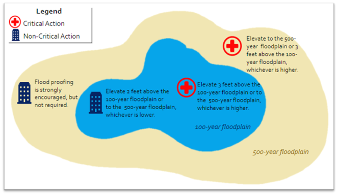
When there is no practicable alternative to siting critical actions involving structures with substantial improvement, or new construction in a 100-year floodplain, recipients must elevate or floodproof the structures to the 500-year flood elevation or an additional three feet above the 1oo-year base flood elevation (BFE), whichever is higher. For areas where the 500-year elevation has not been established, applicants must elevate or floodproof the structures an additional three feet above the BFE.
ii. Non-critical Actions
For non-critical actions involving structures with substantial improvement, or new construction in a 100-year floodplain, recipients must elevate or floodproof the structures to the 500-year flood elevation or an additional two feet above the BFE, whichever is lower. For those areas where the 500-year flood elevation has not been established, applicants must elevate or floodproof the structures an additional two feet above the BFE.
b. Actions within the 500-year floodplain
i. Critical Actions
For critical actions involving structures with substantial improvement or new construction in the 500-year floodplain, recipients must elevate or floodproof the structures to the 500-year flood elevation or an additional three feet above the BFE, whichever is higher.
In coastal locations, there may be rare occasions in which the established 500-year flood elevation is lower than the BFE. In those circumstances, when applicable, recipients must elevate or floodproof the structures an additional three feet above the BFE.
ii. Non-critical Actions
For non-critical actions involving structures with substantial improvement or new construction in the 500-year floodplain, NEH encourages but does not require organizations to elevate or floodproof the structures to the 500-year flood elevation or an additional two feet above the BFE, whichever is higher.
In coastal locations, there may be rare occasions in which the established 500-year flood elevation is lower than the BFE. In those circumstances, when applicable, recipients are encouraged to elevate or floodproof the structures an additional two feet above the BFE.
B. Encouragement to mitigate against flood hazards
NEH strongly encourages organizations to consider floodproofing and other mitigation actions for all projects to further protect the long-term use and value of the proposed project.
1. Floodproofing and other mitigation measures
Examples of floodproofing include elevating buildings; modifying landscaping features; moving and protecting property; dry floodproofing (e.g., installing watertight shields for windows and doors, using sealants and membranes to reduce seepage of floodwaters through walls, reinforcing walls to withstand the pressures from floodwaters); and wet floodproofing, which allows floodwaters to enter and exit the structure (e.g., installing flood vents, using flood damage-resistant building materials, protecting service equipment by locating them above the anticipated flood elevation). Examples of other mitigation actions include risk assessment, inventorying assets, assessing vulnerability, and creating a mitigation plan. Categories of actions institutions can take to protect against flooding include prevention actions such as preemptive reduction of hazard-related loss through specific measures taken early on in the land development process, and property and resource protection actions such as floodproofing and removing cultural resources from flood-prone basements and renovating flood-prone basements. See Integrating Historic Property and Cultural Resource Considerations into Hazard Mitigation Planning (FEMA).
2. Historic Properties
The integration of historic properties and cultural resources is critical to include in comprehensive mitigation planning. Though not all mitigation measures may be appropriate or compatible for historic structures particularly, there are options for facilities to decrease their vulnerability to flooding. For projects involving a structure listed on, or eligible for, the National Register of Historic Places or a State Inventory of Historic Places, NEH strongly encourages the use of The Secretary of the Interior’s Standards for Rehabilitation and Guidelines on Flood Adaptions for Rehabilitation Historic Buildings.
IV. Definitions
100-year flood: flood levels that have a 1% chance of occurring in any given year and have an equal chance of occurring every year, regardless of whether they occurred in previous years.
500-year flood: flood levels that have a 0.2% chance of occurring in any given year. It also can occur in the next year regardless of whether it occurred in previous years.
Base Flood Elevation (BFE): the height that water is estimated to rise in a 100-year flood. The BFE is identified on a FIRM for zones starting with A and Z.
Critical action: any activity for which even a slight chance of flooding would be too great because such flooding might result in loss of life, injury to persons, or property damage or loss. This means a project that provides or involves essential services or irreplaceable resources, utilities, or other functions that could be potentially damaged beyond repair, destroyed, or otherwise made unavailable by flooding. Examples of critical actions are constructing or substantially improving a health center that serves vulnerable populations or constructing a building that stores critical records needed for a local government to continue functioning. NEH makes the final determination if an activity is a critical action facility type and project activities.
Critical records (vital records): records that are fundamental to the functioning of an organization and necessary to the continuance of operations. Many different types of records could be considered vital records, and an exact list will vary by institution. Examples of critical records include records an organization needs to continue functioning or to reconstitute after an emergency (i.e., emergency plans and directives, orders of succession, delegations of authority, staffing assignments, program records) and records needed to continue the most critical operations under emergency conditions and to resume normal operations after an emergency. They also include records needed to protect the legal and financial rights of the organization and individuals directly affected by its activities (i.e., accounts receivable, titles, deeds, deeds of gift, contracts, licenses and long-term permits, payroll, insurance).
Flood Insurance Rate Map (FIRM): official map of a community on which FEMA has delineated the Special Flood Hazard Areas (SFHAs), the Base Flood Elevations (BFEs), and the risk premium zones applicable to the community.
Flood Insurance Study (FIS): compilation and presentation of flood risk data for specific watercourses, lakes, and coastal flood hazard areas within a community. When a detailed flood study is completed for the FEMA National Flood Insurance Program (NFIP), the information and maps are assembled into an FIS. The FIS report contains detailed flood elevation data in flood profiles and data tables.
Floodplain: the area subject to inundation from within the 100-year and 500-year flood events.
Floodproofing: the modification of individual structures, their sites, and their contents to protect against structural failure, to keep water out, or to reduce effects of water entry.
New construction: the construction of a new structure, replacement of an existing structure, or expansion of the footprint of an existing structure.
Structure: a walled or roofed building, including mobile or temporary office trailers.
Substantial improvement: any repair, renovation, or other improvement of a structure, the cost of which equals or exceeds 50% of the market value or replacement cost of the structure. Substantial improvement does not include the repair, reconstruction or other improvement of a structure listed on, or eligible for, the National Register of Historic Places or a State Inventory of Historic Places.
V. Procedures
1. Applications
An applicant proposing projects that involve structures with substantial improvement or new construction shall review a FIRM/FIS to determine if the project site is located within the 100- or 500- year floodplain and indicate if the project potentially involves a critical action. The NEH Federal Preservation and Environmental Officer will make the final determination as to whether a proposed project is a critical action. The information shall be documented on the Site Conditions section of the application package. Instructions for reviewing FEMA National Flood Insurance Program (NFIP) Maps are included in the Notice of Funding Opportunity.
The NEH FRM Standard information will be collected with Site Condition question C.8 of the application which asks: Is the project site located in either a 100-year or a 500-year floodplain (including new site features, such as new buildings, additions, fences, parking lots, signage, etc.), or will the project adversely impact flood flows, discharge stormwater, increase base flood levels or potentially support development in a floodplain? Does the project involve a critical action? Include an 8 1/2” x 11” excerpt of the Flood Insurance Rate Map image (FIRMette) from the FEMA Flood Map Service Center with this attachment. Clearly mark the location of the facility and include the National Flood Insurance Program Panel Number.
The Federal Emergency Management Agency provides a tutorial on how to make a FIRMette. Additional technical assistance on accessing and reading maps may be obtained by contacting the NEH Federal Preservation and Environmental Officer at @email,
2. Offer/Award
If a project recommended for funding is located in a 100- or 500-year floodplain and the FFRMS and NEH FRM Standard applies, the offer or award letter shall include the potential FRM compliance requirements.
VI. Post Offer/Award
If NEH needs additional information regarding the project scope or location, the NEH Federal Preservation and Environmental Officer and Program Offices will continue to work with the recipient to determine if the project is a critical action or not. The NEH Federal Preservation and Environmental Officer will make the final determination as to whether a proposed project is a critical action.
If elevation or floodproofing is required, the recipient must provide certification and evidence of intent to comply with the standard. The recipient should record this information in the eGMS grant file. If the recipient does not comply with the requirements, NEH shall either work with the recipient and identify and communicate expectations for meeting the compliance requirements. If the recipient will not comply with the requirement, NEH may consider other corrective actions under 2 CFR § 200.208: Specific conditions.
Direct questions to @email.