Although the Jamestown settlement may have seemed like the edge of the world to its English colonists, it was, in fact, in the middle of a thriving empire, ruled by the Algonquin Indian leader Wahunsunacock, better known as Powhatan. In December 1607, Jamestown's John Smith was first brought to meet the Indian chief at Werowocomoco, Powhatan's seat of power in the Tidewater area of Virginia.
"Werowocomoco was designed and constructed over several centuries to convey a central place in Tidewater political and religious life, a role that continued in the early relationships with the English," says anthropology professor Martin Gallivan. "From Werowocomoco, Wahunsunacock dominated an impressive social network through which gifts, tribute, and power flowed."
Historians could not pinpoint the location of the village with any certainty until 2001, when archaeologists Dave Brown and Thane Harpole approached landowners Bob and Lynn Ripley about artifacts Lynn had found on their three-hundred-acre farm in Gloucester County, fronting the York River.
"Every time it was a low tide, every time it rained, every time the ground was plowed, and I would go out and collect everything . . . and Indian artifacts seemed to accumulate and accumulate," says Lynn Ripley, pointing to her collection of pottery shards, arrowheads, pipes, copper, and artifacts. By late 2002, Randolph Turner of the Tidewater Regional Office of the Virginia Department of Historic Resources had visited the site and was convinced that it was the place Smith described in his 1608 book, A True Relation.
"Excitement began building at the thought that we were placing our feet on the ground that could have been walked on by Powhatan, John Smith, and Pocahontas," says Lynn.
With a grant from the National Endowment for the Humanities, archaeologists continue to uncover evidence that confirms that the farm, about fifteen miles north of Jamestown, was the seat of Powhatan's empire. Long, narrow ditches, copper artifacts, post holes, and pottery shards indicate that this forty-five-acre swath of land on Purtan Bay was both sacred and politically significant to the Powhatan Indians who inhabited it. "We're literally rewriting Virginia history through these archaeological investigations," says Turner.
"From the early colonial accounts, we know that Werowocomoco was a place of extraordinary power, and the results of our excavations indicate that we need to expand our understanding of the village's role in the Powhatan landscape," says Gallivan, who teaches at the College of William and Mary and is a member of the Werowocomoco Resource Group conducting the excavation.
Much of what we know about the Powhatan comes from the writings of Smith. Smith recalls how two hundred Powhatans kidnapped him and over the course of several days led him from village to village, culminating with Smith meeting Wahunsunacock:
Arriving at Werawocomoco, their Emperour proudly lying uppon a Bedstead a foote high upon tenne or twelves Mattes, richly hung with Manie Chaynes of great Pearles about his necke, and covered with a great Covering of Rahaughcums: . . . hee kingly welcomed me with such good wordes, and great Platters of sundrie Victuals, assuring mee his friendhips, and my libertie within foure days.
The leader made sure Smith saw the extent of the Powhatan dominion, estimated to have covered more than six thousand square miles and supported a population of about fourteen thousand people among more than thirty tribes. The Powhatan lived in separate villages led by their own chiefs, weroances, but they operated under Wahunsunacock's centralized political system, sharing a language, social structure, religious beliefs, and cultural traditions.
Smith would witness how Powhatan brought commanders under his aegis, sometimes by persuasion, but often by force; how at opportune times he provided the English at the James Fort with maize and provisions that kept them from starving; and how he carefully orchestrated events, rituals, and meetings to acquire followers' fealty and promote his political agenda.
"We are coming to see Powhatan as a very politically savvy individual. We see his actions in this process, understand that there are two competing cultures, each one trying to subjugate the other," says Brown. "Both Powhatan and John Smith are individuals who are powerful and charismatic in this story, and it is impossible to disassociate the two."

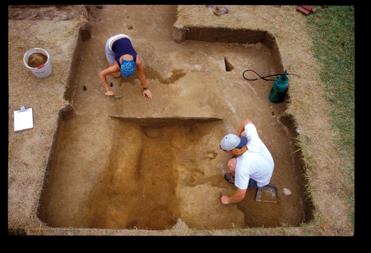
An excavation holds evidence of ditches that date to Werowocomoco
Courtesy of Martin Gallivan
An excavation holds evidence of ditches that date to Werowocomoco
Courtesy of Martin Gallivan
The archaeological team is uncovering clues to understanding what life was like for Powhatan society. Copper artifacts with the same chemical "signature" as those found at Jamestown provide evidence about the evolution of the Powhatan chiefdom. Before the English arrived, Wahunsunacock and his weroances obtained copper from the Monacan to the west. When tribal warfare cut off trade with that tribe, Wahunsunacok looked to Jamestown as a new source, and it is this Jamestown copper that today is found at Werowocomoco.
Soil analysis provides information about what the Powhatan grew and in what quantities, an important consideration when surplus crops such as maize could be bartered for copper, shell, and deerskins—items that would bestow prestige on their Powhatan owners.
It is, however, the ditches on the Ripley farm that have archaeologists excited. Long and narrow, they are located about one thousand feet back from the water, measuring more than seven hundred feet in length. Radiocarbon dating confirms they are of American Indian origin, 1400—1460. Their placement and construction suggest that the Powhatan deliberately created discrete regions to differentiate sacred space from secular. Supporting this theory are thin, delicate pottery shards found on the eastern portion of the site in contrast with thick, everyday pottery found in the western part.
"The western area toward the York River could be the more secular portion, the eastern area the more restricted, making access to it perhaps of a sacred nature," says Turner.
Distinguishing sacred space from secular, Turner explains, could have helped Wahunsunacock consolidate his power, especially if he chose to situate his residence on what was considered sacred ground. Smith writes that Wahunsunacock's residence was located "thirtie score" from the river; this would place it fifteen hundred to eighteen hundred feet from the waterfront and in the sacred area.
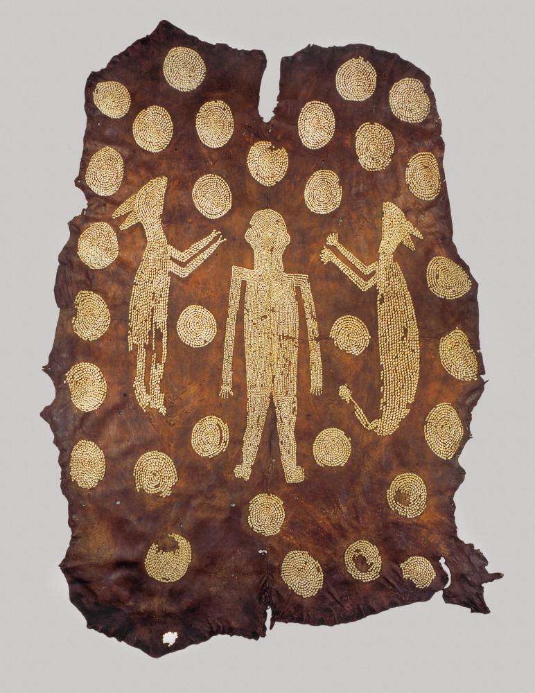
Powhatan's deerskin and shell mantle found its way to England via John Smith.
Copyright Ashmolean Museum, University of Oxford, UK/Bridgeman Art Library

Powhatan's deerskin and shell mantle found its way to England via John Smith.
Copyright Ashmolean Museum, University of Oxford, UK/Bridgeman Art Library
By considering archaeological evidence in conjunction with Smith's writings and maps, historians are forming a more accurate portrayal of Powhatan society.
"Powhatan social organization was defined by sharp inequities of status, authority, and wealth," writes Gallivan. "As envisaged in Smith's map of Virginia published in 1612, the Powhatan polity consisted of 'kings' howses', where weroances resided, and 'ordinary howses' along the rivers of the Coastal Plain."
A map that the Spanish ambassador to England, Don Pedro de Zúñiga, sent to the Spanish king, Philip III, in September, 1608, helps confirm Werowocomoco's setting.
"The similarity between this map's representation of James Fort and the archaeological evidence at Jamestown Island suggests parallels may be possible between the map and features at Werowocomoco," says Gallivan.
The Zúñiga map situates Werowocomoco on Purtan Bay. The map's two concentric Ds surrounded by a circle of dots may represent the ditches archaeologists today find so compelling.
"We think the ditches roughly match the concentric double Ds, but so far we're still tracing them," says Brown. "The exciting thing for us is that so few villages from this period have been excavated."
Brown observes that radiocarbon dating of artifacts and soil samples suggest the site was a sacred spot for hundreds of years before the English arrived. "We know the ditches go back at least four hundred years before contact," says Brown. The status of Werowocomoco as holy ground could be why Powhatan chose it for his operational base. The reasons he abandoned it in 1609 are still speculation —perhaps it was to get away from the increasingly troublesome English.
The Werowocomoco site provides learning opportunities. Each year, students from nearby College of William and Mary do fieldwork as part of Gallivan's summer course. Last year, about eight hundred fourth graders from Gloucester County convened at the Ripley farm twice a week during June to talk to the archaeologists, see the excavation, and take part in activities such as recreating Powhatan's mantle (the original is at the Ashmolean Museum in Oxford).
Danielle Moretti-Langholtz leads the archaeology team's efforts to build partnerships with descendents of the Powhatan. Eight American Indians sit on the Werowocomoco Virginia Indian Advisory Board, which guides the research and excavations. Native partners supporting the research include the Chickahominy, Mattaponi, Nansemond, Pamun-key, Rappahannock, and Upper Mattaponi tribes.
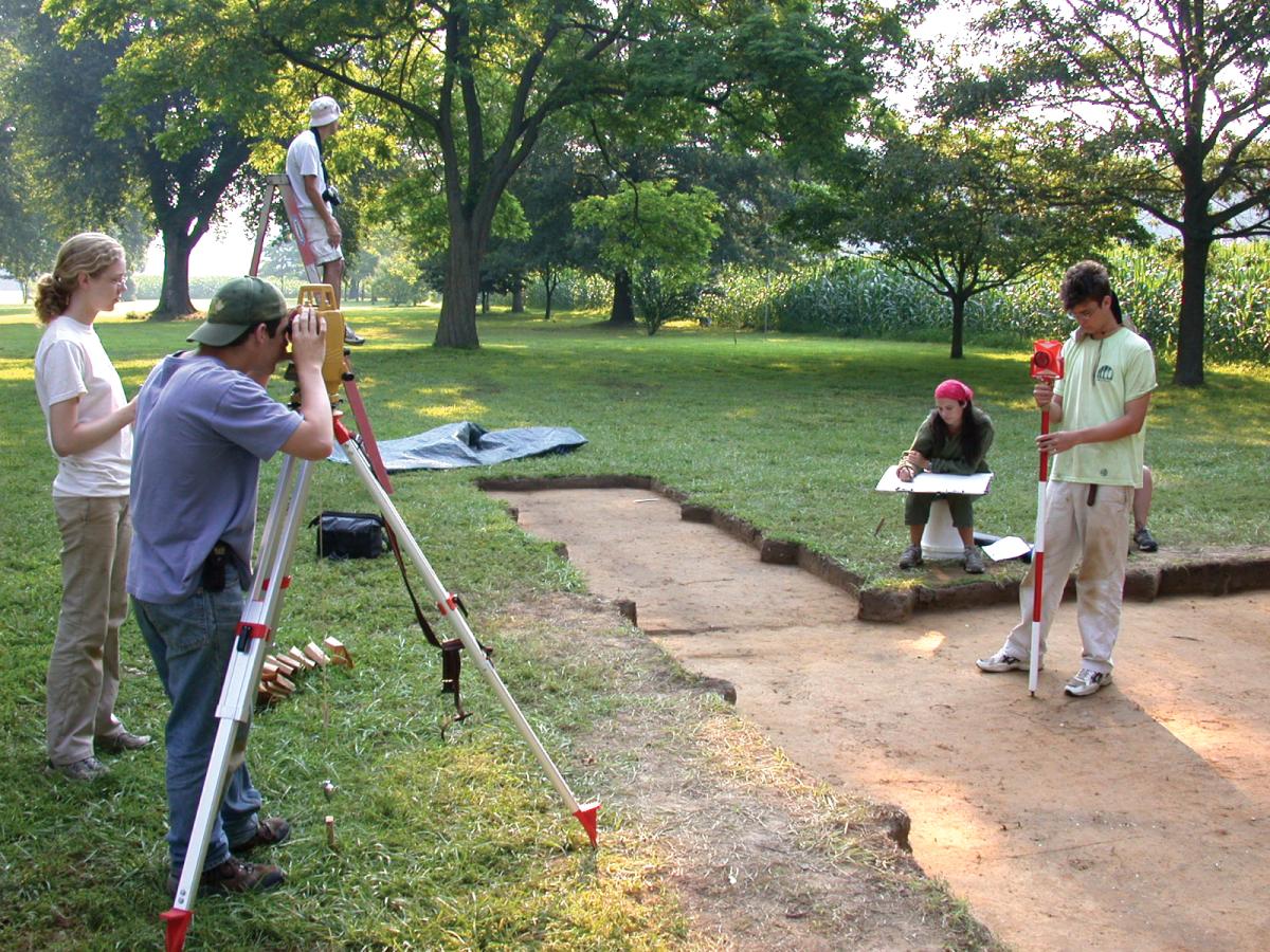
Field school students use a laser transit to record features of the excavation
Courtesy of Martin Gallivan

Field school students use a laser transit to record features of the excavation
Courtesy of Martin Gallivan
As more students, American Indians, archaeologists, journalists, and tourists visit the site, an attitude of reverence is encouraged. "Balancing public engagement, Native collaboration, and homeowner privacy is not simple in such locations," writes Moretti-Langholtz.
One compromise is a short field season-from late May to late June-when there is nearly unlimited access for the archaeologists and American Indian population. At the end of each season, the archaeologists cover up the digs to preserve the landscape until the next year. "We want to treat this location with respect, and also make sure that the Indians be involved in Werowocomoco and whatever takes place here," says Lynn Ripley.
"Indians were living here in what today we call Virginia long before the English arrived on their shores," says Turner. "When you consider that they were inhabiting these lands at least fifteen thousand years ago, the last four hundred years become far less significant if viewed from this broader perspective of Virginia history."