Preserving the Cultural Heritage of the Ancient Near East and the Mediterranean World
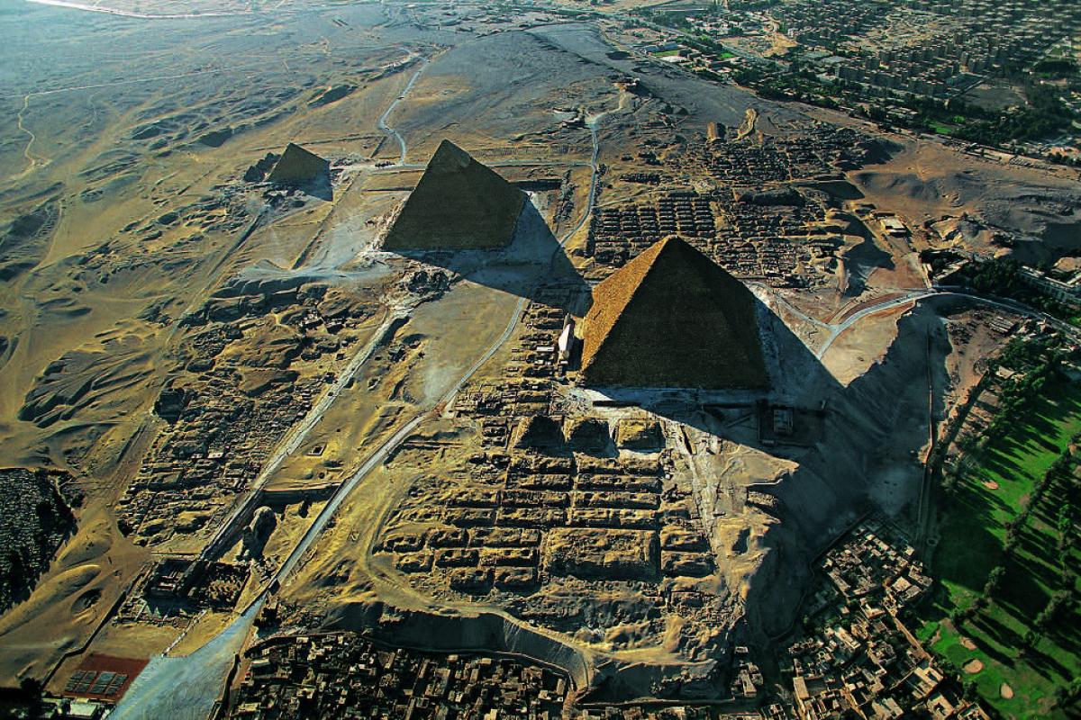
Aerial view of the Giza Necropolis, looking west
Courtesy of Marcello Bertinetti/Archivio White Star and the Giza Project, Harvard University.
Aerial view of the Giza Necropolis, looking west
Courtesy of Marcello Bertinetti/Archivio White Star and the Giza Project, Harvard University.
With the ongoing destruction of cultural sites and collections in the Middle East, the protection of archaeological and historical resources in that important region has become an international priority. Through the Division of Preservation and Access the NEH is working to preserve and make accessible large and valuable collections of art and archaeological remains, cuneiform texts, seal impressions, and coins and manuscripts from the Near East and across the Mediterranean. These materials represent some of humankind’s first efforts at recording history and shed light on the ancient languages, artistic traditions, and the social, political, and economic environments of numerous Mesopotamian and Mediterranean cultures and city-states. The six projects featured below underscore the rich, yet fragile, legacy of these ancient civilizations.

Reading the Signs: Digital Editions of Ancient Cuneiform Sign Lists
Early in their histories, the peoples of Mesopotamia, an area that covers much of modern-day Iraq, devised writing systems to record administrative activities and to commemorate their rulers’ achievements. Dating to the fourth millennium BCE, Sumerian is the earliest written language in the region. It appeared in cuneiform, a script named for the shape of the impression made by the instrument that ancient scribes used to write on clay tablets (cuneus = wedge in Latin). Other cultural groups also incorporated Sumerian writing styles—the earliest of these were the Akkadians, speakers of a Semitic language, who adapted cuneiform for their own uses. As evidenced in preserved clay tablets and stone monuments, however, the exchange of linguistic elements between the Sumerians and the Akkadians was mutual, and by the third millennium BCE, southern Mesopotamia was extensively bilingual, and the confluence of cultures influenced not only language but also rulership, education, and religion.
Fundamental to our understanding of the relationship between Sumerian and Akkadian cultures are lists of cuneiform signs that were compiled to help Akkadian readers understand Sumerian. For more than 2,000 years, ancient Mesopotamian scholars used these sign lists as a reference and a teaching tool. At present, the sign lists are difficult to access for modern research; most appear in print editions without English translations. With support from the NEH, a team at the University of California, Berkeley, under the direction of Professor Niek C. Veldhuis, is working to translate, transcribe, image and provide free online access to of Mesopotamian cuneiform sign lists. The lists will be available via the Digital Corpus of Cuneiform Lexical Texts and the Open Richly Annotated Cuneiform Corpus, which aggregates records of cuneiform texts from multiple institutions Access to these resources is critical for future research on the history of cuneiform writing, of ancient education and Mesopotamian intellectual culture, and study of early languages of the Near East.
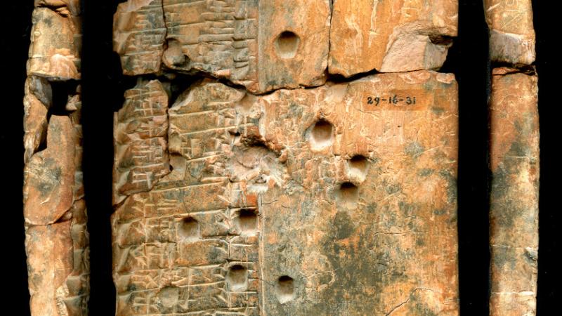
The Royal Inscriptions of the Neo-Assyrian Period Project
The kingdom and empire of Assyria, based in what is today northern Iraq, existed for almost one and a half millennia (ca. 2000 to 610 BCE) and stretched, at various times, from Turkey in the north, to Egypt in the south, and to the highlands of Iran in the east. Like its Sumerian and Akkadian predecessors, Assyrian culture was highly literate, and its rulers produced inscriptions commemorating their deeds on clay tablets and cylinders and on stone stelae and difficult-to-reach mountain cliffs across the empire. Thousands of texts written in the Sumerian and Akkadian languages were discovered at sites like Babylon, Nineveh, and Nimrud in the 19th and 20th centuries. These royal inscriptions contain information on the history, religion, economy, and culture of the peoples living in this vast region, many of whom are also mentioned in the Hebrew Bible and in Classical sources. However, many of these inscriptions have yet to be published or translated into English.
Thanks to the efforts of experts at the University of Pennsylvania, under the direction of Professor Grant Frame, and with NEH grant support, modern editions of these texts are now being prepared and published online, also on Open Richly Annotated Cuneiform Corpus, enabling study by researchers at all levels, from school and college students to teachers who are concerned with ancient history and culture, to museum professionals, and to the public at large. When complete, data from the project will be fully integrated into the Cuneiform Digital Library Initiative and the Open Richly Annotated Cuneiform Corpus.
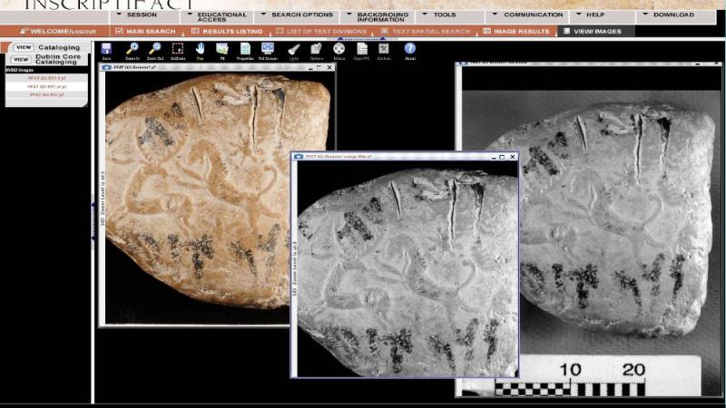
The Persepolis Fortification Archive
During the middle of the first millennium BCE, the area that had been ruled by Assyrian kings came under control of the Persian king Cyrus the Great, who pushed the borders of his empire, based in modern-day Iran, far to the east, encompassing Pakistan and Afghanistan, as far as the Indus Valley. By 500 BCE, the Persian empire had become many times as large as the Assyrian empire at its greatest extent, encompassing Egypt, Anatolia, Syria-Palestine, and the eastern Greek cities.
In 1933, Oriental Institute archaeologists working at one of the empire’s royal residences, Persepolis, clearing the ruined palaces of Cyrus’ Achaemenid Persian successors, found tens of thousands of clay tablets in two small rooms of a bastion in the fortification wall at the edge of the great stone terrace of the royal palace complex. Since 2006, the Persepolis Fortification Archive Project, based at the Oriental Institute of the University of Chicago, under the direction of Professor Matthew Stolper, has cataloged and recorded these tablets with texts in Elamite and Aramaic languages and impressions of thousands of seals. The tablets belong to a single administrative archive from the reign of King Darius I (522-486 BCE), and study of them has revealed the record keeping techniques and infrastructure of an administration that supported the society around the imperial court.
Study of the tablets and seals has transformed our understanding of the Achaemenid empire, which lasted until 330 BCE. The archive is the most important source of information for research on languages, communication, society, institutions, religion, art, and history of the empire's Persian heartland. Staff at the Oriental Institute are making electronic images--using both conventional digital photography, large-format high-resolution scans, and dynamic interactive imagery--of the tablets and linking them in a common electronic research environment to editorial, analytical, and cataloging information compiled by a team of specialists. To date, the project team has taken more than 3,000,000 images of more than 11,000 tablets and fragments, made available transliterations, translations, and linked images of more than 5,000 texts, linked also to identifications of more than 3,200 distinct seals. The results are freely available via the Online Cultural Heritage Research Environment based at the University of Chicago, and through InscriptiFact (the online application of the West Semitic Research Project at the University of Southern California) as well as through other collaborating Web sites. As with the Mesopotamian Sign Lists and the Neo-Assyrian Royal inscriptions, the Persepolis Fortification Archive will be integrated with the Cuneiform Digital Library Initiative, based at the University of California, Los Angeles.
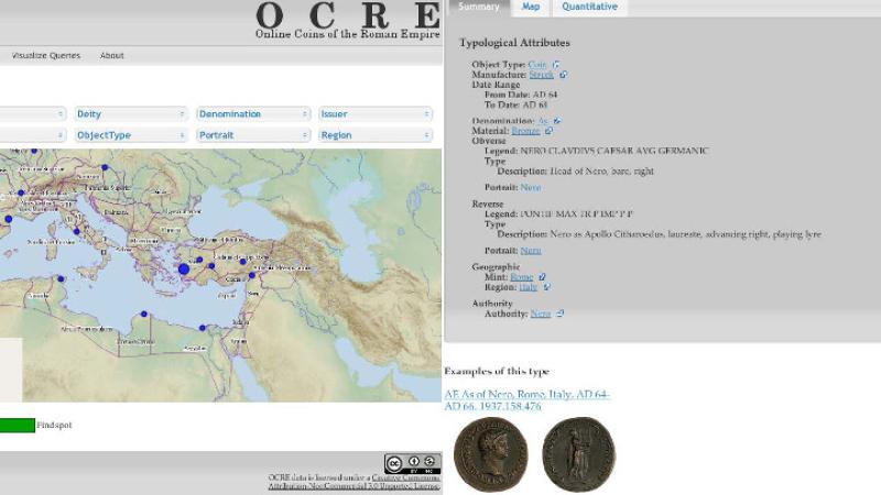
Roman Coinage
Roman coins are a ubiquitous resource, and like the earlier clay tablets, they represent a form of writing that can reveal many layers of information about their makers and users. In the Roman Empire, most major cities had their own mints and issued coinage that commemorated the emperor, local magistrates, as well as deities or other attributes of the city. As we shift to an electronic economy in today’s world, it is salutary to be reminded how much information one small piece of metal could convey. Made of silver, gold, or bronze, Roman coins have weights and denominations (denarius, sestertius, aes, for example) that tell us about their mineral sources and the economy. Legends and images provide art historical sources on representations of the emperor; and the locations at which coins are found (findspots) can reveal much about the circulation of people, goods, and money in the ancient world. When part of a larger hoard, coins provide absolute dates that help to build chronologies, the backbone of archaeological discovery.
Supported by the NEH, Online Coins of the Roman Empire (OCRE) is a joint project of the American Numismatic Society (ANS) and the Institute for the Study of the Ancient World at New York University under the direction of Professor Andrew Meadows. OCRE is a revolutionary new tool designed to help in the identification, cataloging, and research of the rich and varied coinage of the Roman Empire. The project will ultimately record every published type of Roman coin from the start of the reign of Augustus in 31 BCE, until the death of Zeno in CE 491 and will create an easy-to-use digital corpus, with downloadable catalog entries, incorporating almost 50,000 types of coins.
Collaborating with museums in Europe and the United States holding significant Roman coin collections, OCRE also draws on findspot information from another ANS-developed resource, Coin Hoards of the Roman Republic, enabling the mapping of the distribution of early Augustan types of coins.
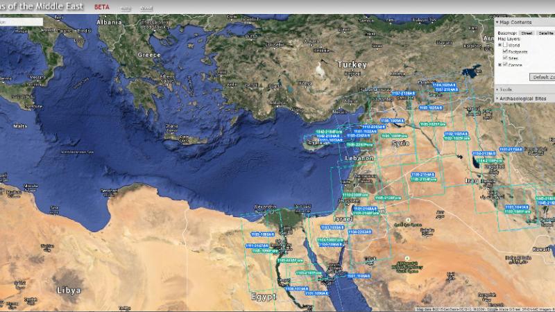
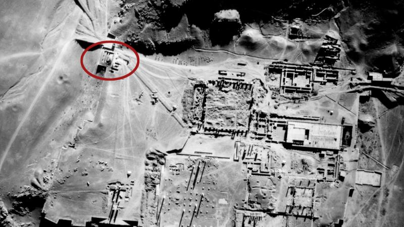
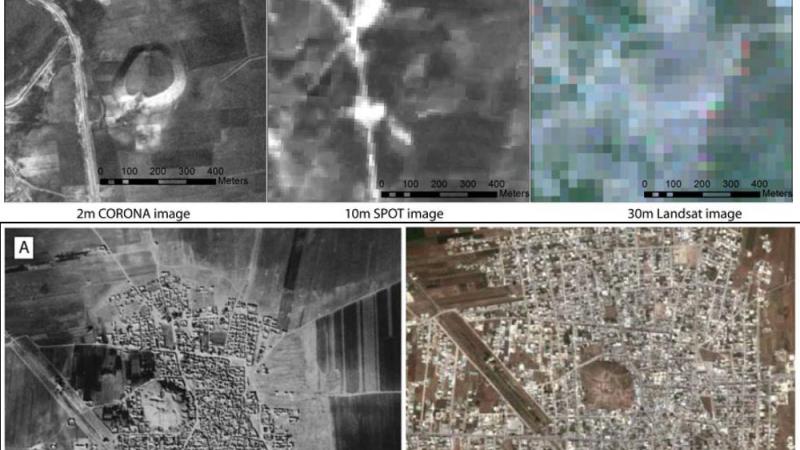
CORONA Project
Two other NEH-supported projects are also offer significant resources for the study of the Ancient Mediterranean and Near East. Both are working to provide broad access to legacy archaeological material from the Middle East and Egypt, respectively. The University of Arkansas’s CORONA Project, directed by Professor Jesse Casana, is creating a digital atlas of archaeological sites based on approximately 4,200 intelligence satellite images that were taken from 1960 through 1972. Declassified in the mid-1990s by the United States government, the images encompass large parts of Europe, Asia, and Africa and display the quantity and distribution of sites throughout specific regions. CORONA imagery is particularly important for archaeologists because ancient sites and features such as roads and canals are clearly visible in the high-resolution images. For regions like the Middle East, where urban development, modern agricultural practices, reservoirs and dams, as well as the current political turmoil, has obscured or destroyed existing antiquities, these images represent an important scholarly resource. In addition to providing open access to optically rectified images online, the CORONA Web site also enables comparison of the 1960s images with contemporary landscapes and provides basic measurement functions, a database of major archaeological sites, and tutorials for more advanced research.
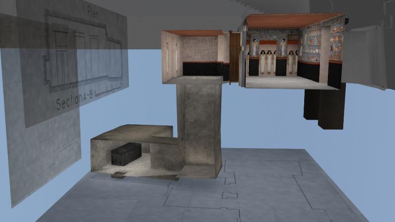
Giza Project
Finally, the Giza Project is a collaborative international initiative to collect, preserve, study and present all archaeological records from the Egyptian Old Kingdom (2600-2100 BCE) sites of the Giza Pyramids and great Sphinx. Based at Harvard University and directed by Professor Peter Der Manuelian, the project builds on the Giza Archives database hosted by the Museum of Fine Arts in Boston and will eventually bring together digital records of objects, notebooks, architectural drawings, plans, photographs, and correspondence from Egyptian collections across the globe. In addition to creating access to this data online in a linked environment, the project will generate a 3-D computer model of the entire site, becoming the central repository and research hub for data on Giza spanning all periods and drawing on collections from museums in Berkeley, Berlin, Boston, Cairo, Leipzig, Philadelphia, Turin, and Vienna. As with the CORONA Atlas Project, the Giza Project aims to provide a model for similar reference resources. In light of recent political turmoil in a number of the emphasized regions, these resources underscore the important role NEH has played and will continue to play in the preservation of cultural resources of the ancient world and their application for research, education, and public use.